New Marine Satellite Services Pricing

boat

Light users in new sectors to benefit from Marine Satellite Services pricing

Inmarsat has just announced new Fleetbroadband marine satellite services pricing packages that focus on the smaller fishing and leisure vessels.

“These plans will help Inmarsat and its partners tap into new and growing markets for light marine vessels,” said Kyle Hurst, Inmarsat’s maritime market manager.

He explained: “The plans, which were launched on 1 April, are designed to appeal to users who are fairly conservative in their requirements for data and voice, sporadic in their use and typically are regionally constrained in their use.”

Marine Satellite Services pricing plans will provide:

  • Capped bills – controlling costs and limiting bills to specific daily, monthly amounts
  • Shorter durations – month at a time pricing plans
  • Inmarsat’s new on-net pricing – more affordable satcom to satcom calls.
  • Applicability for all data types – focus on much lighter fleetbroadband users who want to send/receive a small amount of data like e-logs.

Kyle said: “These plans are designed to appeal to users who, up until now, may have been interested in using Fleetbroadband but were wary about the commitment involved.

“They are prepared to pay a certain amount every month, but they want value-added services that provide strict controls and limits on utilisation and therefore cost.

“We believe that these plans offer partners a great opportunity to break into new maritime markets.”

Mobile Satellite Communication kits provide relief in Indonesia

house

Just a dot on the vast map of Indonesia, the Mentawai Islands are no less vulnerable to nature’s wrath as tsunamis in 2004 and 2010 proved. The latest tsunami struck the islands of Sipora, Pagai Utara and Pagai Seletan in October 2010 as a three-metre (nine-foot) wave swept through 20 villages, killing at least 435 people and leaving 20,000 homeless.

The Inmarsat constellation, the worldwide leader in mobile satellite communications supported essential data and video footage using airtime and equipment supplied by TDCOM – a subsidiary of Inmarsat distribution partner Vizada. Inmarsat-sponsored Télécoms Sans Frontières (TSF) was one of the first on the scene, establishing Broadband Global Area Network (BGAN Service) equipped communication centers and providing IsatPhone Pro Satellite Phone for voice calls in the field.

Realizing that the islands needed their own emergency telecommunication facilities, Justin Waller, TSF manager for the Indonesia project, said: “There is a lack of communication infrastructure on the islands, with landlines and mobiles only covering the major towns. Our project was designed to improve the communications capability of local organizations involved in disaster response.”

TSF provided portable BGAN Service kits as well as a range of other sat com equipment, the cost of which was born by the Humanitarian Aid department of the European Commission (ECHO). The two largest kits established a communications hub to operate at the center of a future disaster response. These were given to Indonesia’s local government disaster response organisation – BPBD Mentawai – and to a major Indonesian non-governmental organization (NGO), Air Putih.

The larger kits contained:

  • IsatPhone Pro handheld satellite terminal plus an IsatDock docking station, antenna and 20 meters of cabling
  • BGAN Explorer 500 terminal
  • Wireless router
  • Notebook computer
  • Multi-purpose fax, scanner, copier and printer
  • Durable Pelican transport case
  • GSM modem, SIM card and credit
  • Honda portable electricity generator
  • Documentation, software and system restore facility on a USB key.

    Four smaller kits containing just an IsatPhone Pro satellite phone and an IsatDock docking station and cabling were supplied for use by other organizations, as were 19 IsatPhone Pro handsets. A substantial airtime credit, valid for four years, was also included. The smaller kits were deployed to several local organizations, including three local health centers run by the district health authority.

Waller added: “The kits and training have been delivered to organizations with the capability of both looking after the equipment and sustaining the skills to use it. All these organizations have operations that extend over the islands and the equipment will be distributed throughout all four of them. Early feedback from organizations has been positive – particularly as regards the IsatPhone Pro.”

Wenger Patagonian Race protected by mobile satellite communications

hikers

South American Adventurers “Protected” with mobile satellite communication.

Perhaps better known as the “last wild race”, the 2011 Wenger Patagonian Expedition Race takes competitors on the annual 10-day challenge, routing them on a secret and isolated route across plains, mountain glaciers, forests and lakes – on foot and by Kayak and mountain bike. The 15 teams were given general, landmark-oriented instructions for the route on the night before the start of the race.

Inmarsat, the world’s leading provider of mobile satellite communications, was chosen by race organizers to provide portable satellite emergency communications equipment and service for the race competitors. Participants are forbidden the use of modern navigational aids such as GPS.

Broadband Global Area Network (BGAN Service) terminals and handheld portable IsatPhone Pro satellite phones, supplied by a local Inmarsat Service Provider, enabled race officials stationed at the checkpoints throughout the course to stay in touch with other. BGAN satellite terminals were also used to relay information back to the official race Headquarters in Punta Arenas, for distribution to Twitter and Facebook feeds, the race website and Chilean and international media.

Held last February, the race was won by British team Adidas Terrex / Prunesco, who claimed their third consecutive victory after completing the course with two days to spare. They endured some of the toughest conditions in the event’s history, including high winds and torrential rain. Eight teams failed even to finish.

“This is an amazing race that tests endurance, skill and determination, and we’re proud to be a part of it,” said Kate Montgomery, Inmarsat land services manager in the Americas. “The event brings together many of the conditions that our clients experience in their everyday business, which makes this an exciting testing ground for our services.” For this reason, mobile satellite communications was chosen as a second line of defense for redundancy communications

iSatphone Pro satellite phone is now data capable…with compression

satellite phone

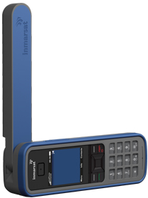
The iSatPhone Pro satellite phone with up to 8 hours of talk time and 100 hours in standby mode operates via the reliable Inmarsat satellite network. The iSatPhone Pro Satellite phone offers the lowest per minute rates in the industry and now the phone is data capable. Now with the help of OCEN’s Mail and OCENS WeatherNet services, the lower bandwidth of the this phone is faster and transformed into a data ready device to be used anywhere on the planet.

iSatPhone data services transmits at a rate that moves about 10 Kilobytes (about half of the information in this blog post) in 60 seconds. Compared to terrestrial data services and other high speed satellite devices like the BGAN service, this is relatively slow, however with compression via OCENS Mail, transmission speeds are up to 15 times faster. Faster data speeds through compression, translates to more cost effective airtime and an overall time savings to free up your schedule to complete other tasks. OCENS Mail is so impressive that Inmarsat used the service in the original beta testing of the phone. OCENS Mail and WeatherNet are compaticle with Windows 7, Vista and XP however the iSatPhone Pro Satellite Phone does not yet work with Mac OS.

Many of our maritime customers require weather information and ocean data; WeatherNet is the ideal solution. Weather charts, route information and other fishing info could take up to 15 minutes to download with bandwidth @ 10Kbps. However, WeatherNet automatically compresses and downloads this information in a fraction of the time. The OCENS Mail service and WeatherNet both provide a software guru which walks you through the iSatPhone Pro set up on your computer which also installs drivers for the satellite phone on your PC

Firmware on the IsatPhone must be upgraded to version 4 in order to enable the data services.. Here is the International Satellite Services Video via OCENS on how to perform this upgrade

iSatPhone Pro Satellite Phone Evaluation

file-236913244-jpg

The company TelAstra was commissioned by Inmarsat to run an independant study of the iSatPhone Pro Satellite Phone to compare it with 2 other handheld satellite phones on the market, the Iridium 9555 and the Thuraya XT. All three phones were tested over a 2 month period in 16 different countries. This evaluation was conducted by Roger Rush who is an independent satellite communications consultant with over 45 years industry experience.

Roger tested the IsatPhone Pro Satellite phone against the competition and used the following 6 criteria. It was determined by this evaluation that the iSatPhone Pro Satellite Phone is the “ultimate combination”

1. Global coverage
2. Robust handset
3. Clear voice quality
4. Reliable network connection
5. Long battery life
6. Easy to use

Marine Satellite Services provides a solution for crew welfare

girl on a boat

Many maritime companies are including “onboard internet services” in the recruitment of prospective employee’s as retention and the welfare of the crew has become a major priority for ship operators.

“Younger crew will, apparently, refuse to join a ship that does not have the internet,” says Inmarsat’s head of maritime business, James Collett.

So the presence of mobile satellite communications onboard is not necessarily good for the bottom line but has become a necessity for the personnel on the vessels.

“Younger ships’ captains and crew joining a fleet will escalate an increase in bandwidth needs because they understand what this facility means to people onboard,” says James.

“Many older captains still have the attitude that it’s nice but not essential, yet can be heard complaining about the five hours it takes for an email to get from shore to ship.”

AP Moller-Maersk, a leading marine shipping company put its crew first by having marine satellite services outfitted on hundreds of their ships.

As archaic as the situation seems, before marine satellite services were implemented, the crew could only make voice calls from a single satellite phone with prepaid sim cards and email restricted to 2 messages daily while at sea. Since the satellite communications upgrade, the crew now has access to unlimited email and internet browsing via a WiFi connection accessible on their laptops in any area of the ship. As an example, the merchant tanker Eleonora allocates roughly 25% of the satellite airtime for business operations such as company voice calls and data transfer with 75% set aside for the crew to communicate with the outside world.

“One of the biggest challenges for seafarers remains the isolation and loneliness while at sea and it’s proven that communications technology reduces the stress of being away from family,” says James.

“There is no getting away from the fact that the web has taken over much of our lives.

“At sea or on land, the digital revolution is running our lives faster with email, smartphone apps, and MP3 music files.

“Many people onboard will run their bank accounts, friendships, and even dental appointments via the web.”

Social networking has become the norm for individuals at sea as a way to keep in the conversations back on the mainland with family and friends via Facebook and Twitter.

“It makes business sense to invest in solutions that gain respect, trust and loyalty from seafarers to prevent their skills and experience being lost,” adds James.

BGAN Service instrumental in Mining Exploration

man talking in front of mine

Broadband Global Area Network (BGAN Service) is unique in offering world wide simultaneous mobile broadband data with voice on a truly portable device. It is also the first such device to offer “guaranteed” 256K streaming for live video and video conferencing.

Based in Perth Western Australia, Haines Surveys uses gravimeters to provide a kind of “X-ray vision” – seeing through rock – looking for clues as to what minerals are present in the ground. Haines personnel travel to the remotest parts of Australia in search of mining opportunities, marking those locations that hold promise using GPS tracking antennas.

In the past, Haines had to send highly paid geophysicists to the sites to gather the data who then often had to travel many miles to find an internet connection so that they could transmit their findings back to the office. The advent of the BGAN Service has greatly speeded up the process by providing on site satellite internet connectivity which allows for locally trained, less expensive technicians to collect the data and then immediately transmit it to the geophysicists back at the office for analysis.

The company’s co-founder and director, Richard Haines had already utilized satcom equipment for remote voice communications. For the past 12 months, more than 22 of their field technicians have also utilized the BGAN Hughes 9201 terminal for data transmission. Geophysicists in the office are able to use email to send detailed instructions to the field technicians directing them to the areas most likely to contain mineral deposits. Armed with the results of this data analysis, the mining companies have a pretty good idea of where to start exploratory drilling.

“BGAN has revolutionized the way we do business. Geophysicists can remain in the office providing essential data analysis enabling mining companies to act fast to exploit new deposits.”

“Gravitational surveying is a game of logistics, which is where BGAN proves vital. It means no more wasted time traveling out of our way to send data back to the office.”

The new BGAN facility has allowed larger raw gravity files to be sent to our Perth of Adelaide offices on a daily basis. Files of up to 3MB are now regularly sent to the office, allowing final processing of the data to be completed that evening.”

“BGAN has removed the need for reprocessing of the gravity data, resulting in a cost saving on average of $5,000.00 per project.”


Madagascar Fisheries are transformed with marine satellite service

boat

Like hundreds of other locations throughout the world, Madagascar is concerned with ensuring future sustainable commercial fishing around it’s coastline for future generations. Madagascar operates an economic exclusion zone up to 200 nautical miles from its coastline with established quotas for different categories of fish. Monitoring teams for the island’s Ministry of Agriculture, Livestock and Fisheries have begun using Inmarsat’s FleetBroadband 150 marine satellite services (FBB150) in order to enhance their surveillance activities.

Estimates show that around 300,000 tons of fish around the island's 5,603 km (3482-mile) coastline are of commercial interest and around 145,000 tons are currently being exploited. Included in these stocks are tuna, shrimp, crab and lobster. The Madagascar Monitoring Centre’s goal is to ensure the rational and sustainable exploitation of marine resources within its exclusive economic zone.

Last year, a three-month maritime field evaluation using a marine satellite services terminal yielded immediate improvements, in fact, it “revolutionized” communication onboard the vessel.

The monitoring vessel had been previously using Inmarsat’s entry-level voice, fax, and 9.6kbps circuit-switched data service Fleet 33.

In addition to enabling the centre to more accurately plan the vessel’s operations and improve its surveillance capabilities, the increased efficiency of the FBB150 also resulted in fuel cost savings.

"Our client reports much improved capabilities. Before the FleetBroadband 150 was fitted it was not possible to obtain, in real time, the positions of other vessels in Madagascar's waters. The vessel had to call the monitoring centre to find out where vessels were", said Satellite Air Time's technical manager Oumesh Tewary.

Equipped with Satellite Airtime's tracking software, the monitoring vessel Atsanta now receives onboard data reports via the FBB150 which are then automatically plotted onto the SP's monitoring software, Babel Solution. The FBB150 was pivotal in an operation in which two vessels fishing illegally were seized. The service allowed coordination of the surveillance of the suspected boats as well as the transmission of real-time information between the Atsanta and the monitoring centre. “These vessels have now been taken over by the Malagasy authorities and may be converted for monitoring use”, says Oumesh.

Under the direction of the Indian Ocean Commission and in conjunction with Mauritius, Seychelles, Comores and Reunion Island, the Atsanta is also supporting a regional surveillance program. This program will provide mutual assistance designed to protect the exclusion zones of each territory.

Because of the tremendous success of the FBB150 trial onboard the Atsanta a local marine operator has recently installed three of the larger Inmarsat FleetBroadband 500 terminals on its vessels.

BGAN Satellite provides “always on” connection on oil rigs

BGAN

Portable BGAN offered by Inmarsat, the world’s leading provider of portable satellite internet and voice solutions, is the only mobile satellite service to offer simultaneous broadband data and voice through a single, extremely portable device. BGAN Satellite is also the first service to offer “guaranteed” data rates on demand – up to 256kbps – for live video streaming and video conferencing.

RigStat LP, the Texas based company started in 2004, makes systems that are the “eyes and ears” for oil rigs and terminals, monitoring them even when they are unmanned during hurricanes. RigStat has conduced most of its business to date in the Gulf of Mexico, using Inmarsat portable BGAN Service to provide an always-on connection for some of its installations, sending data every hour over the Inmarsat network. As its reputation grows, it is finding customers in South America, Australia and other regions.

RigStat Pro’s patented system collects data from a variety of sensors on submersible, semi-submersible, jack-up rigs and oil terminals. Technicians on shore regularly receive data transmitted via the on-shore web portals from the systems, using the data to monitor the status of the assets. Although the system was designed to monitor the assets during inclement weather, it has practical application for year-round operation in normal conditions, such as checking the rig’s location in relation to nearby vessels and other platforms.

First deployed in the Gulf of Mexico in 2005 during Hurricanes Katrina and Rita – two of the most destructive weather events ever – the system proved its worth giving an almost real-time view of the location, wind speed and motion of a rig which had broken free of its moorings. After that, word began to spread within the oil business.

RigStat is a pioneer system in offering this level of detailed monitoring from unmanned platforms during extreme weather. Why is that important? It’s standard safety practice for oil companies to evacuate their rigs as a hurricane approaches, first switching off all systems and main power supplies and taking a GPS fix of the rig. However, sometimes this is not enough.

As one company learned the hard way, it costs a lot of money to retrieve, repair and re-moor a storm dragged oil rig. After Hurricane Andrew in 2004, one company flew over the last known location of its rig and found that it had gone. It took the company more than a day to locate the rig some 70 miles from its former location and then about a week to tow it back into position.

Any system that can significantly minimize these costs by communicating precise, virtually real-time status and location of a rig during and after a hurricane is highly valuable to energy companies. It might even prevent damage from happening in the first place. It will certainly help company personnel in deploying equipment and manpower after the storm in order to progress with remedial work as quickly and cost effectively as possible.


Inmarsat wins Provider of the year award for Satellite Services

Inmarsat logo

Inmarsat has been named Satellite Services Provider of the Year in the annual Digital Studio awards during Cabsat and Satellite MENA in Dubai.

The Digital Studio Awards bestowed the prize of Satellite Provider of the Year to Inmarsat earlier this year. Inmarsat’s products and services have contributed to the major growth of both the production and broadcast industry overseas.

“We are truly honored to receive this award and remain committed to offering our premium services to professionals and organizations in the broadcast industry,” said Helene Bazzi, Inmarsat’s senior area manager for the Middle East and Africa.

Media companies all over the world, like CNN for example, utilize BGAN services to transmit video, large file uploads and high resolution images in areas of the world that don’t have terrestrial connectivity. BGAN is the only mobile satellite services technology that offers guaranteed data rates on demand including simultaneous voice and high speed data capabilities.